Proven GIS expertise
PaM brings over 15 years of experience in developing enterprise GIS and geospatial software for governments and partners in developing countries.
About Us
We are a GIS system provider delivering software for revenue mobilization, land digitalization, city planning, emergency response, taxation and more.
PaM brings over 15 years of experience in developing enterprise GIS and geospatial software for governments and partners in developing countries.
We build integrated, cloud-enabled systems that connect desktop, mobile, and web platforms to deliver realtime geospatial solutions.
PaM’s PaMGIS geospatial platform is designed to address core public sector challenges through tightly integrated GIS workflows.
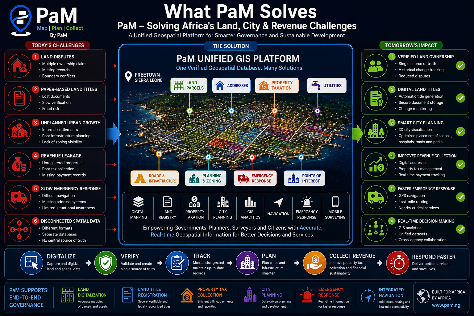
We are a global team of engineers and IT specialists creating geospatial applications for public sector digital transformation. Our focus is on solving the geospatial problems faced by developing countries, with solutions that support revenue mobilization, land administration, urban planning, taxation, and emergency management.
Make spatial intelligence accessible and actionable for governments, partners, and communities.
A connected public sector where decision makers use real-time geospatial data with confidence.
PaM partners with government agencies, development organizations, and infrastructure teams across Africa and beyond.
Leadership
Experienced engineers and public-sector specialists leading geospatial transformation.

Co-Founder & CTO
Moses comes with almost two decades of experience developing GIS software for governments and the private sector. Moses holds a PhD in navigation, estimation and control of aerial vehicles. Prior to working on PaMGIS, he used his GNSS and INS expertise in develop robust geospatial, navigation and control solutions for drones and later for the New Glenn rocket during his time at Blue Origin. He leads the development of PaMGIS and is responsible for our technical vision and product strategy.

Head of Software Development
Sam leads software development for PaMGIS, driving product engineering, platform architecture, and day-to-day delivery across the team. He holds a degree in Computer Science and Economics from Macalester College and brings deep industry experience — five years at SAP AG, followed by senior engineering management roles at Target and Visa. Sam specializes in building large-scale web applications and leading engineering teams to ship reliable, scalable software.

Senior Software Engineer
Brian Williams is a senior software engineer and technology consultant with over a decade of experience designing and deploying enterprise-grade applications. He holds advanced academic qualifications in Computer Science, a doctoral degree in Information Technology, and a Project Management Professional (PMP) certification. He has experience in both private and federal environments.

Senior Engineer
Yasir Zia is a senior engineer with extensive experience in cloud infrastructure and DevOps practices. He has a strong background in designing and managing scalable, secure, and efficient cloud environments. Yasir holds a Bachelor’s degree in Computer Science and has worked on various projects involving cloud architecture, automation, and infrastructure management. He is skilled in leveraging cloud technologies to optimize performance and ensure reliability.

Head of Property Taxation Delivery
Amara Mudir Sumah leads property taxation delivery for PaMGIS, overseeing field data collection, deployment, and rollout of the platform for revenue authorities. A Computer Science professional with a background in social innovation and ICT-driven development, he focuses on turning PaMGIS into measurable outcomes for governments — accurate property registers, efficient mass appraisal, and improved revenue collection. He works closely with local teams to drive adoption, training, and capacity building across deployments.